It's raining weather models!
-
- from Shaastra :: vol 01 edition 02 :: Jul - Aug 2021

Scientists are using better data sets, and a deeper understanding of atmospheric processes, to improve weather and climate forecasting.
Cumulonimbus clouds, multilayered and extending high up into the atmosphere, weave beautiful patterns in the sky but pose serious danger to aircraft. They can shake up a plane flying through them, cause damage to communication systems, and make the pilots feel disoriented. Aircraft inside such clouds can spin out of control when the turbulence becomes severe. Occasionally, when tornadoes are lurking around, the aircraft can even break into pieces. Pilots avoid such clouds, often staying as far as 40 kilometres away from them.
At the Indian Institute of Tropical Meteorology (IITM) in Pune, Thara Prabhakaran and her colleagues hire planes and fly above, below - and even right into - the cumulonimbus clouds in the early stages of formation. Specially trained pilots fly the Beechcraft B200 aircraft, which has scientific instruments on the wings and inlets to get the air through another set of instruments in the cabin. The pilot and the passengers, however, must bear the discomfort and the risk. The aircraft shudders vigorously when it enters the clouds, bobbing up and down severely when hit by updrafts and downdrafts. When the aircraft is not pressurised, as was the case in some of her early missions, the eardrums of the passengers ache, and their head seems to spin.
Most of Prabhakaran's air missions are to study cloud seeding, but she uses the opportunity also to understand cloud formation and behaviour. Among other things, she is looking to figure out how aerosol particles in the clouds influence the weather. Aerosols can act as condensation nuclei, which are small particles on which vapour condenses to form water or ice. No one understands precisely how these processes work. Clouds, in general, are a poorly understood phenomenon, but they have a significant influence on weather and climate. "We are only beginning our studies," says Prabhakaran.
During her flights, Prabhakaran measures the size, number and other aspects of particles in various clouds. Her aim is to predict whether or not a cloud will precipitate as rain.
Prabhakaran's work is part of a series of research projects at IITM to understand the physics of the world around us, and to use this understanding to improve forecasting of weather and climate. More than ten years ago, when such efforts began at IITM, monsoon weather forecasting in India was based largely on empirical observations and statistical models. Such forecasts were famously inaccurate, as we would expect from models that did not incorporate enough atmospheric physics, apart from suffering from paucity of data and inadequate computational power. While data collection and computational facilities have improved over the past few years, scientists are far from fully understanding the processes that drive weather and climate. "Prescription of physical processes into the models is one of the weakest links in weather forecasting," says IITM Director Ravi S. Nanjundiah.
IITM had begun monsoon modelling as a small project more than a decade ago. At that time, the India Meteorological Department (IMD) used to give forecasts based on its own models that were partly statistical and partly dynamical. Land, Atmosphere and Ocean models were all worked out separately but not integrated. Incorporating the interwoven dynamics of the three ecosystems was a necessary step in building good prediction models.
As IITM began this work and its models improved, the IMD began slowly replacing parts of its models with those of the Pune-based institute. The National Monsoon Mission gave a fillip to model-building in the country by funding research and creating high-performance computing facilities, apart from collecting more data. Till 2017, IITM gathered data from square grids, each a side of 37.5 kilometres. With improved computing facilities, this has shrunk to roughly 12 kilometres, a very high resolution for short-range forecasts when compared to those from other institutions.
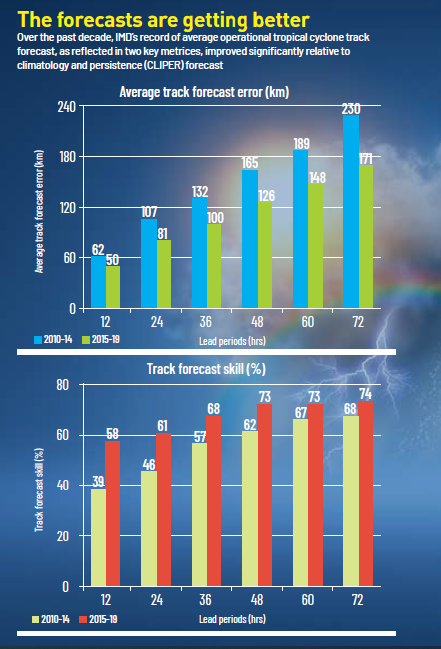
High-resolution models alone do not guarantee good forecasts unless they are backed by sound data and a deep understanding of the physical and biological processes that drive weather and climate. Data collection has been sparse over India, especially over the oceans on either side of the subcontinent, but it has improved in the past few years. And although many atmospheric processes are still not well-understood, research projects are providing hints into the possibilities for forecasting over the next decade.
For example, the Bay of Bengal is a key player in the development and subsequent behaviour of the monsoon. This area of the ocean has peculiar characteristics due to the large amounts of fresh water flowing from the Ganga and the Brahmaputra. This fresh water pushes the salt water in the ocean back, causing the formation of steep salinity gradient layers in the Bay of Bengal. Since salt water heats up faster than fresh water, the salinity gradient creates a steep temperature gradient on the sea surface. In the long run, it raises the ocean's temperature and gives rise to a multitude of weather fronts in the Bay of Bengal. These weather fronts are the reason the Bay of Bengal fosters more cyclonic activities than the Arabian Sea does.
Older models did not integrate such observations from the ocean and the atmosphere. Suryachandra A. Rao, professor at IITM, brought them into the model by mapping the winds and circulation over the Indian Ocean and the Indian subcontinent using the data from satellites and instruments set up in the oceans. The recent discovery of the stratified structure of the Bay of Bengal and its mixing processes are now integrated into the models.
For a long time, Rao had been researching ocean-atmosphere coupling, an interaction that initiates the Indian summer monsoon and cyclones. Rao and his colleagues built systems that connect and refine the collected data before being sent as an input in the model, systems that capture the rich physics in the interplay between the ocean and the atmosphere. They are used to derive empirical laws - those derived from observation - for the physical parameters that are not well-understood and defined in the model. Convection is one such parameter derived from the ocean-atmosphere interplay. Cloud microphysics is another, with its empirical relations derived from flight observations and experiments. "This coupled-data assimilation technique has improved our forecasts by providing error-minimised data for the model," says Rao.
Suryachandra Rao and his colleagues have built systems that capture the rich physics in the interplay between the ocean and the atmosphere.
A better understanding of cloud formation is expected to create a significant impact on forecasts. In fact, lack of real knowledge of cloud physics has for long been one of the serious shortfalls of weather models. Although empirical laws are now incorporated into the models, it is hard to give long-range forecasts without understanding cloud physics. A key player in this physics is aerosols, small particles that are emitted from the earth's surface and linger in the air for a long time.
Aerosols play a significant role in the formation and evolution of cumulonimbus clouds. They are all around us, both near the surface and high up in the atmosphere. Some aerosols are natural in origin: sea salts, dust, volcanic ash, carbon from forest fires. Human-made aerosols are exhausts from automobiles and power plants, cigarette smoke, smoke from cooking stoves and so on. About 90% of the aerosols are natural in origin. However, human-made - or anthropogenic - aerosols are increasing in volumes. Since they are also concentrated in a small region, like cities, anthropogenic aerosols may have a disproportionate influence on the weather - and, by extension, on the climate.
During her flights, Prabhakaran measures the size, number and other aspects of particles in various clouds. Her aim is to predict whether or not a cloud will precipitate as rain, and how the location of the cloud affects its precipitation. From her flights, she found a direct impact of pollution on cloud physics at a micro level. Clouds formed in a polluted region have a greater number of particles and tend to live longer than the clouds formed in a clean environment. Since the water content of clouds is a constant quantity, clouds with fewer particles form larger droplets and thereby result in rains earlier than clouds with a large number of particles. Since clouds reflect solar radiation back into space, polluted clouds reduce the solar radiation reaching the earth's surface by remaining in the atmosphere longer than those with fewer aerosols. They finally produce rains at much higher altitudes than the conventional clouds formed in clean environments.
Prabhakaran also works on nimbostratus clouds, dark grey clouds that bring heavy rainfall. Nimbostratus clouds contain both warm rain droplets and ice particles. Such a mixed phase is directly associated with extreme rainfall and thunderstorm events, but their physics is not incorporated in the models. Such events are increasing in number due to climate change, but scientists cannot predict them well enough due to a lack of understanding and data.
Prabhakaran's team observed an ice-splintering mechanism in the nimbostratus clouds, where bigger drops at colder temperatures start freezing suddenly, followed by their breaking apart. This results in the formation of too many ice particles, thereby leading to heavy snow and rain upon melting. Such a mechanism had not been noticed before her observations during flights.
There are many other important cloud phenomena that are not understood. For example, clouds in the Himalayas form at temperatures ranging from -3° Celsius to -40° Celsius. Their ice nuclei particles grow, decay and precipitate below freezing point. When the precipitation reaches clouds below them, at warmer temperatures, they melt and cause the other clouds as well to precipitate. This process is not incorporated in the model yet.
As meteorologists begin to understand weather better, they start extending their computations for longer and longer periods to see what lies in the future as climate. An improved understanding of the physics of weather helps improve climate models as well, and IITM had tweaked the weather models to be relevant for studying long-term climate change as well. Specifically, good climate models need inputs on the relationship between the oceans and the atmosphere and the land. And there is an additional aspect of the oceans that is relevant for climate but not for weather prediction: how the biology of the ocean changes with temperature.
Oceans are the heat sinks of the earth, as they absorb more than 93% of the heat generated due to global warming. Warmer oceans tend to expel dissolved oxygen, thereby affecting organisms living in that region. The Indian Ocean has so far warmed by 1.2° Celsius, and is expected to warm up quickly in the future.
Roxy Mathew Koll uses an earth system model developed by IITM to study the Indian Ocean's warming, and employs this model to predict the climate of the Indian subcontinent till the end of the century. Koll is also working to understand how phytoplanktons in the oceans would interact with the warming water and influence the climate, apart from affecting the food chain. The past six decades have seen a substantial decrease in these phytoplanktons in the Indian Ocean, but no one knows whether this decrease is due to climate change.
Roxy Mathew Koll is also working to understand how phytoplanktons would respond to a warming ocean and their effect on the food chain.
The western part of the Indian Ocean has large amounts of fish, and decreasing phytoplanktons and continued Indian Ocean warming might result in this productivity region becoming an ecological desert. "If, at some point in the future, we can incorporate fisheries in the IITM model, that might further improve our understanding of how greenhouse gases and climate change would welcome us in the future," says Koll. As the phytoplanktons are a part of the carbon cycle, their decline may have a feedback loop into climate of the future. But not much research has gone into this aspect.
Investments in the past decade in India have improved the collection of data, computational facilities and the understanding of the earth as a system. And yet, the science of weather and climate has huge gaps that researchers are now addressing. Although it may not be possible to create the weather that we like, accurate prediction can reduce the damage and help us to adapt to climate change.


Seeing through the skin, with X-rays
The Nobel Prize-winning discovery that took the world by storm, even as its discoverer renounced the fame that followed.

In perfect sync
Starlings and locusts seem to make decisions in concert in a striking exhibition of groupthink. This offers clues to how complex systems work.

The 'smart grid' fix
India's transition towards decarbonisation relies on a tighter embrace of renewable energy. It's important to get it right.

Have a
story idea?
Tell us.
Do you have a recent research paper or an idea for a science/technology-themed article that you'd like to tell us about?
GET IN TOUCH