No smoke without fire
-
- from Shaastra :: vol 05 issue 01 :: Jan 2026
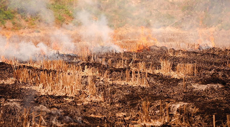
Stubble-burning farmers are slyly evading satellite detection. Researchers, therefore, favour multisourcing pollution data.
Among the multiple features of INSAT-3DS, an Earth observation geostationary satellite launched by the Indian Space Research Organisation (ISRO) in February 2024, is the Mid-Wave Infrared channel on its imager. Being highly sensitive to temperature, it produces clear images of smoke, fires, and sea surface temperatures, and also distinguishes between smoke and clouds.
Researchers at the Ahmedabad-based Space Applications Centre (SAC), who developed the payload, studied the images to test the output. The satellite captured forest fires over Nainital and a major fire on the Jaipur-Ajmer highway in December 2024, despite its poor 4-km spatial resolution. It also focused on post-kharif farm fires, an annual practice in North India from September to November, when farmers clear fields to sow the rabi crop. The satellite had accurately captured the fires with peak activity recorded at around 5 pm (bit.ly/SAC-fire). The finding was not a surprise. There was already talk about farmers shifting stubble burning from morning to evening to avoid detection by satellites. The INSAT 3DS provided proof.
HIDE AND SEEK
The Indian Agricultural Research Institute, which provides official data on farm fires, and most other agencies rely on the U.S.-based National Aeronautics and Space Administration's polar orbiting satellites for imagery. These satellites orbit over India twice a day; once between 10.30 am and 1.30 pm, depending on the satellite, and then between 10.30 pm and 1.30 am. Aware of this movement, farmers shifted the timing of burning to avoid being captured on camera. Geostationary satellites, on the other hand, provide continuous coverage of an area; INSAT-3DS provides a fresh image every half hour. However, since these satellites are at a higher altitude – around 36,000 km above the equator – their resolution is not as good as that of low Earth-orbiting polar satellites, which have a resolution of up to 350 metres.
The high readings observed by the monitors in 2024 could not be explained by the satellite-based data, which showed a sharp drop.
The SAC team decided to verify the temporal shifting pattern and studied open-source data from the geostationary European Meteosat, which provides a fresh image every 15 minutes. "We noticed that in 2020, the fires peaked at 1.30 pm and subsided by 3.30 pm. In 2024, the peak had shifted to 5 pm," says Mehul Pandya, Group Director at SAC's Space and Environmental Sciences Group. "Further, the window in which the burning was done too had narrowed to evade detection," he says (bit.ly/burning-shift).
Similar conclusions were drawn independently from a clutch of studies. The Council on Energy, Environment and Water (CEEW), a Delhi-based research and policy organisation, highlighted in a report published in October 2025 the limitations of the current suite of satellites in accurately recording farm fires. The organisation procured very high-resolution satellite imagery for two consecutive days in November 2020 over an area of around 74 sq km in Punjab's Sangrur district. The images, purchased from Google Earth Pro, showed 169 fires over a two-day period. The researchers compared the images with the polar satellite images. One of them, the VIIRS sensor, recorded only seven fires during the period, while the MODIS sensor recorded none.
The Japan-based Research Institute for Humanity and Nature ran a project called Aakash from 2020 to 2025 to address air pollution caused by farm fires and to encourage social transformation through better practices. Considering that the Central Pollution Control Board (CPCB) had air quality measuring instruments only in urban centres, with monitoring largely focused on the capital region, the team set up 30 low-cost monitors across the rural areas of Punjab, Haryana and Delhi to capture emissions of Particulate Matter 2.5, a major pollutant, primarily consisting of soot. The high readings for farm fires observed by the monitors in 2024 could not be explained by the satellite-based data, which, in contrast, showed a sharp drop. When the researchers, working on a computer simulation, adjusted the model to reflect peak burning at 6.30 pm rather than in the afternoon, the simulation matched real-world sensor data much better (bit.ly/emission-crop).
₹3,623.45 crore
allotted between 2018 and 2024 for farm stubble management
140 million tonnes
paddy straw generated in India annually
43.56 million tonnes
kharif rice harvest from Punjab, U.P., Haryana in 2024
The Noida-based International Forum for Environment, Sustainability and Technology (iFOREST) studied data from a suite of polar-orbiting and geostationary satellites through the end of the 2025 season. While MODIS/VIIRS data of 2025 indicated that active fire counts had reduced by 92% in Punjab and by 90% in Haryana after peaking in 2021, the Meteosat observations showed that over 90% farm fires in Punjab in 2024 and 2025 occurred after 3 pm, while in 2021, only 3% of the fires occurred that late. In Haryana, the shift to post-3 pm fires began as early as 2019, "thus MODIS/VIIRS has been underestimating fires in Haryana for several years," says the recently published iFOREST report (bit.ly/iFOREST-report).
The report noted that while images of burnt areas showed a clear reduction of 25-35% in both States, these were significantly lower than the levels suggested by active fire counts (around 95%). Fire counts in other nearby States of Madhya Pradesh, Uttar Pradesh and Rajasthan, the report noted, are rising. The Union Ministry for Environment, Forests and Climate Change issued a statement in December 2025 claiming that there were 5,114 farm fires in Punjab, and 662 in Haryana that year, a reduction of 53% in both States over the previous year and over 90% since 2021 (bit.ly/2025-farmfire). The smog over the National Capital Region through November 2025 belied official figures.
UP IN SMOKE
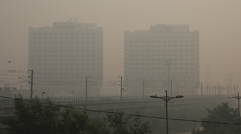
North India's winter smog is a complex phenomenon exacerbated by multiple factors. The pollutant load largely comes from vehicles, industries, construction dust, and biomass burning. While the first three factors remain constant throughout the year, biomass burning spikes from September. Farm fires are the chief cause of biomass burning between September and November and can contribute up to 35% of the PM 2.5 load, while domestic heating is the primary reason for biomass burning from late December to February. "Half of Delhi's urban population resides in low-income housing. Also, there are 56 villages within Delhi's limits. Burning wood, cow dung cakes, and coal rises when the temperatures dip," says Chandra Bhushan, President and CEO, iFOREST.
A 2023 study by the Indian Institute of Technology Kanpur had observed that burning of biomass was responsible for 70% of the winter haze in Delhi in January and February, with "uncontrolled biomass burning for residential heating and cooking" being the source (bit.ly/domestic-heating). "Yet, action to curb these activities by providing cost-effective alternatives is lacking in the pollution control plans," says Bhushan. Farm fires happen only for three months, whereas biomass burning for cooking takes place year-round.
Temperature inversion and the lower altitude at which the aerosols mix in the atmosphere trap pollutants closer to the surface on winter evenings. "The shift in stubble burning to later in the day worsens air pollution. During the day, when the mixing [of pollutants with moisture] happens at a greater altitude, there is more scope for pollutants to disperse," says Prabir Patra, who led the Aakash project. "Rural Punjab, where stubble burning is the highest, actually has the heaviest load of PM 2.5, only it is not measured by the CPCB," he adds.
Lack of wind on certain days worsens the smog. "Wind speed is the primary meteorological element that decides the air quality of the day in the capital," says Mohammad Rafiuddin, Programme Lead, CEEW.
The recent findings on farm fires indicate glaring gaps in data collection, which will have an adverse bearing on policy and mitigation plans. "We cannot manage what we cannot measure accurately," says Ishan Kochhar, Programme Lead, iFOREST.
"There is clearly a case to opt for an ensemble of data sources for accurately measuring air pollution," says Bhushan. Each source comes with limitations. Existing geostationary satellites are unable to pick up smaller fires. Satellites are not good at distinguishing between burnt and half-burnt fields. Farmers use multiple methods to clear fields. Some harvest the main residue (up to 6 ft high) and burn the remaining stubble in the field. Others collect the residue in one place and burn it together. Satellite fire counts, therefore, do not give the entire picture.
"The main takeaway is that we need to make better instrumentation for geostationary satellites with finer resolution," says Pandya. The SAC is developing payloads for the polar-orbiting G20 satellite mission for environmental and climate observation, and it will also include instrumentation to study forest fires. The mission was first proposed at the G20 in New Delhi in 2023. The Aakash project calls for air pollution monitoring networks in rural areas. A more pervasive and multi-pronged approach holds the key to accurately assessing farm fires.


Banking on seeds
Seed conservation is an essential part of food security. But it’s not just the state: researchers are conserving traditional crops, too.

It's raining solutions
New technologies are being harnessed to make sense of and cope with the age-old monsoon weather pattern.


Swati Mohan has Mars on her mind
NASA engineer Swati Mohan on the significance of the Mars missions for future space explorations.

Have a
story idea?
Tell us.
Do you have a recent research paper or an idea for a science/technology-themed article that you'd like to tell us about?
GET IN TOUCH