The drones business is soaring
-
- from Shaastra :: vol 03 issue 03 :: Apr 2024

The drones applications industry is soaring. Now, the focus has turned to regulation.
When Jayant Sirohi talks about drones, it is from the perspective of someone with a bird's-eye view of the landscape — much like that of the crewless aerial vehicles. The Professor of Aerospace Engineering and Engineering Mechanics at the Cockrell School of Engineering of the University of Texas at Austin, U.S., is among those who designed the current class of drones some 25 years ago. Not surprisingly, it was to Sirohi that the ride-hailing company Uber turned for directions and technology a few years ago when it wanted to take the aerial route to ferry people and pizzas.
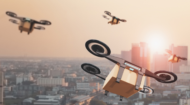
The former student of the Department of Aerospace Engineering at the Indian Institute of Technology (IIT) Madras thinks that the technology is robust enough. But the future challenge is making drones autonomous, just like self-driving cars that may become commonplace in the foreseeable future. He envisages that drones, controlled from a central place, should be able to deliver cargo at multiple locations before heading back to the station.
"But it's premature to think, as some people worry, that the skies will be filled with drones doing deliveries (over the next few years). The technology has reached a point where we need regulations to kick in to ensure that everything works, without damage to property or life," says Sirohi, who designed and flew his first drone with a 6-inch rotor diameter back in 2000.
In recent years, there has been an explosion in the number of drones in use. In 2023, there were more than 7.6 million drones in the civilian space, up from just 4.6 million units five years ago (see: A bird's-eye view of drones). The market size is expected to grow to $55.8 billion in 2030 from $33.9 billion in 2023.
Radar-mounted drones can map an entire city while flying on its outskirts and capture quality images in all weather conditions, or even at night.
Many factors have triggered the spurt in the civilian use of drones. "Around 15 years ago, there came a confluence of technological breakthroughs, which revolutionised the development of rotor drones, even though these technologies were not being developed keeping them in mind,'' observes Sirohi.
The first of these was the advent of the lighter lithium-ion (Li-on) batteries, which had much higher power density than nickel-metal hydride batteries, which were popular then. Vertical Take-Off and Landing (VTOL) and hovering are power-intensive manoeuvres, and Li-ion made it possible to make these nifty moves and also gave the drone a longer flight run. His first quadcopter drone, powered by a nickel-metal hydride battery, in the early 2000s, stayed airborne for barely a couple of minutes, he recalls. Today, a standard flight is of around 30 minutes.
The advent of small, brushless DC motors, which needed low maintenance compared to their brushed predecessors, increased the machine's efficiency. The third push came from advances in electronics and sensor development. Miniaturisation allowed developers to put microprocessors on board, with complex algorithms for not just on-board stability but progressively for a range of tasks and autonomy, he says.
"If somebody talked of drones, say, 20-30 years ago, it would have typically meant fixed-wing Predator type of drones, which are used for defence and military applications," says Dhwanil Shukla, Assistant Professor in the Department of Aerospace Engineering at IIT Bombay. "They are pretty much like aircraft, but scaled-down versions because they are not meant to carry passengers. But avionics and other equipment on board were of a similar grade as passenger-carrying aircraft."
The drone changed drastically in the last couple of decades with reliable and ultrafast wireless communication technologies, extremely tiny electronic components and availability of navigation systems, such as GPS and handheld communication devices.
Shukla compares the drone platform with the mobile phone. Just as a handheld device with internet connectivity became a platform for diverse applications — from cameras to GPS — the drone provides an aerial platform for a range of tasks. "Most drone applications can be slotted under three heads: cameras, payload (from cargo to data collection equipment) and tanks (for spraying). Within these verticals, the imagination is the limit," says Shukla.
Once there was a cheaply available flying platform, developers used it for a range of applications — especially in areas that were out of human reach or which required great expenditure, he says.
SATELLITE SERVICE
Enthused by the immense potential offered by drone technology, Tapan Misra, formerly with the Indian Space Research Organisation, leveraged the platform for radar imaging. Misra, who retired as Director of the Ahmedabad-based Space Applications Centre in 2021, developed a new type of drone that uses an innovative radar technology, hitherto used in remote sensing satellites and high-altitude aircraft. Mounting such a specialised radar system, called synthetic aperture radar (SAR), on drones opened up a new range of possibilities for mapping and surveillance missions.
The SAR is superior to regular cameras as it has an oblique or side-looking capability, which increases the range under coverage. SAR-mounted drones can map an entire city while flying on its outskirts. Also, unlike optical cameras, SARs can capture quality images in all weather conditions, or even at night.
Misra developed an algorithm combining the best features of L-band and X-band SARs. L-Band (24-cm wavelength) SARs have high penetrative power, but give low-resolution images. On the X band (3-cm wavelength), the images are of high resolution, but the penetration is poor: it cannot see through foliage or clouds.
Just as a handheld device with internet connectivity became a platform for diverse applications, the drone provides an aerial platform for a range of tasks.
He mounted this hybrid radar onto a low-flying drone and tested it in 2023 over the forested areas of Haringhata in West Bengal. He also created an algorithm for motion compensation and procession of the SAR to account for the distortion from strong winds. "We got an image resolution that is three times the industry standard for L bands," says Misra, who has set up a company, Sisir Radar, which will provide satellite-quality imagery at a fraction of current costs. A satellite costs ₹800 crore; his drone will cost about ₹5 crore. He hopes the product will interest the military, agriculture and mining sectors.
CIVILIAN NEEDS
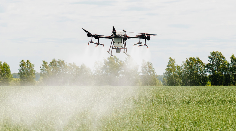
Drones are a platform for innovation. The last few years have witnessed a boom in their deployment across sectors. While developed initially for defence, they are being used in civilian applications, including precision agriculture, terrain mapping, traffic control, fire-fighting, pest control, surveillance, entertainment and structural inspections.
Drones came in handy when locusts attacked crops in several parts of Rajasthan and Haryana in 2020. Tiny unmanned flying machines were used to locate locust swarms while they rested at night. Since drones are not allowed to operate at night, they began precision spraying at dawn, while the insects were still at rest. Some months ago, law enforcement agencies were able to detect opium-yielding poppy plantations tucked away between fields of tall crops with the help of drone-borne cameras, says Aakash Sinha, Founder of Omnipresent Robot Tech, which partnered in these operations.
At IIT Madras, a team led by Aerospace Engineer Manikandan Mathur plans to use drones for monsoon studies. It is working on a project to design and deploy drones to collect real-time data of small-scale weather events close to the coast — up to 300 km from the shore — where the dynamics of tides, boundary currents, and topography produce small events quite different from the large-scale behaviour of the monsoon over the vast ocean. Since these are localised data sets, satellite imagery is not adequate. Tethered weather balloons, on the other hand, have a limited range. The project proposes to send drones, especially designed to withstand the monsoon, out to sea to collect data, such as sea surface temperature, atmospheric velocity and pressure profiles, which would then help them develop better climate models.
At a recent exposition, Adani Defence and Aerospace showcased its drone, Partha, which can move along tall buildings and uses its onboard methane detector to detect gas leaks. "It can detect a leak even at the parts per million (PPM) level," says Mohnish Kapoor of Partha Project.
Researchers from the U.K. and Switzerland have also demonstrated the possibility of using swarm drones mounted with 3D printers to construct a tall structure (bit.ly/3D-drone). While it might not be economically feasible at present, it shows the potential for future constructions, especially in remote areas.
EVOLVING DESIGNS
Fixed-wing Unmanned Aerial Vehicles (UAVs) have been around for decades and mainly used by the military. These craft, however, needed an airstrip and had restricted in-flight possibilities. The quadcopter, while in existence, was still a work in progress.
While new uses of drones are evolving, the design of the drone, too, is being adapted. Quadcopters may be the masters of VTOL, but a rotor-powered flight is power-consuming, especially compared to fixed-wing flights. This has led to the advent of hybrid drones, which take off and land using rotors, but switch over to fixed-wing flights while flying. Drone company ideaForge's hybrid drone, SWITCH, for example, has an endurance of up to 2.25 hours (against one hour for that range of quadcopter) and a range of 15-20 km (against a 5-km range for standard drones), says Co-founder Rahul Singh of the start-up, a pioneer and leader of drone technology in the country. While hybrid drones have also been designed for the military, academia and business circles are looking to adapt them for civilian uses.
"We are working towards a future in which drones will be so ubiquitous that people will not even be aware of them working in the background. And their autonomy will improve to a stage where they need bare human intervention in decision-making," says Singh.
FUTURE BUZZ
A recent drone race in Switzerland gives a glimpse of future drones. An AI-trained drone developed by the University of Zurich edged past human-piloted drones to win the race by half a second. The drone, however, didn't fare as well when it was placed in a situation different from the ones it had been trained in.
The bigger challenge, however, will be in regulating unmanned vehicular traffic — an issue that will emerge with more drones deployed for civilian use, especially with Beyond Visual Line of Sight (BVLOS) drones: uncrewed aircraft that are out of the direct visual line of sight of the remote pilot.
What, for instance, will happen when a drone meets with an obstacle mid-flight over an urban area? Self-driven cars come to a halt in such a situation, but drones cannot hover indefinitely. Commercial drones come with some collision avoidance capabilities, and researchers are working on improving these technologies. But the biggest challenge in the next-level deployment of drones is seen in the regulation of operations, says Jonathan M. Aitken, who teaches at the University of Sheffield's Department of Automatic Control and Systems Engineering. Unmanned traffic control is a big area of research across the globe.
Work is continuing on drones — such as reducing noise generation, creating compacter stacks of hardware and software, making drone flights safer and also experimenting with newer fuel options. The first stage of bettering drones is over, and the focus now is on regulations. "Technology has now reached a stage when it has to wait for the regulations to catch up," Sirohi says.
See also:


'Astronomy is one of the last frontiers for physics'
Nobel Prize-winning astronomer Didier Queloz on the cosmic significance of his exoplanet discovery.


Have a
story idea?
Tell us.
Do you have a recent research paper or an idea for a science/technology-themed article that you'd like to tell us about?
GET IN TOUCH