

On thin ice
-
- from Shaastra :: vol 05 issue 09 :: Sep 2026
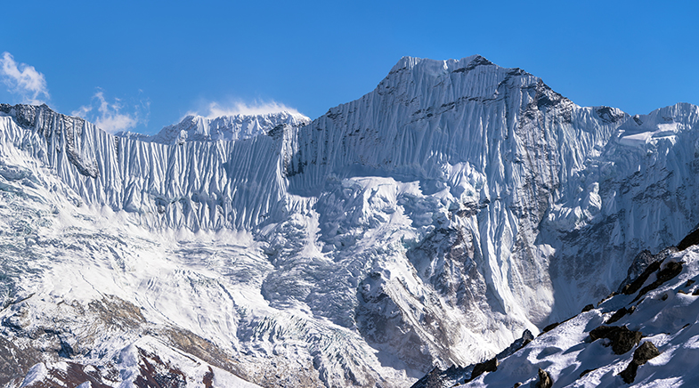
A glaciologist flags the risks of Nepal-like natural disasters from Himalayan hanging glaciers.
Glaciologist Anil V. Kulkarni is considered one of the world's leading authorities on Himalayan snow and ice cover. In this interview with Shaastra, Kulkarni, who was until recently Distinguished Scientist at the Indian Institute of Science (IISc), explains why glacial tragedies such as the one that wracked Nepal in late August 2026 are hard to predict, and how the impact of natural hazards can be minimised. Edited excerpts.

The glacier movement and avalanche that set off the Nepal floods of August 2026 occurred in the high Himalayan range, and the impact was felt far away, in the lower reaches. Can such events not be predicted and people alerted in time?
This is a very unique kind of event. The cryosphere, the region where glaciers exist, has numerous risks. Some are predictable; some are not; others, we are still trying to understand how they develop.
This particular case involves hanging glaciers. There are other risks in high-mountain areas, such as glacial lake outburst floods (GLOFs). These are relatively predictable because we can map the lakes using satellite images, understand how they have increased in size, and estimate the volume of water they store and how large they could become.
Using satellite observations and modelling, we can identify which regions are likely to be affected if a lake bursts. What is difficult is to predict exactly when it will burst. That may be possible with proper field instrumentation, including pressure sensors and other sensors.
In theory, this is possible, but in practice it is difficult because these are remote locations, often with no human settlements. It is difficult to install and maintain instruments on the ground.
We saw one such disaster in Sikkim in 2023. What happened in Nepal was similar to what happened in Chamoli, Uttarakhand, in 2021, but with greater intensity.
Are hanging glaciers more lethal?
To understand this, we have to understand the geomorphology. Glaciers are landforms made of ice. If their volume becomes very large over time, they slowly move into the valley. Because of their size, they erode the surface, creating a broad valley. Such glaciers become valley glaciers. They may not necessarily cause the kind of disaster seen in Uttarakhand or Nepal, but they can form lakes, leading to GLOFs.
A hanging glacier is different. It is associated with a steep mountain slope. Due to icing, snowfall, and other processes, large amounts of ice accumulate there. It may not be large enough to modify the topography, but it can still be large enough to hang over the slope.
As temperatures rise – and temperatures in mountain regions are rising faster than the global mean – there is more melting at the surface. Meltwater can penetrate through crevices and reach the base, weakening the bond between rock and ice. This is associated with degradation of permafrost. Once that frozen condition is degraded, the mass can slip and fall.
In this case, the hanging glacier was located above a large deglaciated valley. The glacier had largely melted away, leaving only a small portion of ice in the upper region. Below it were loose rocks, debris and moraines.
When the hanging glacier fell, the consequences were enormous. Some estimates suggest that it fell from a distance of 1.5-2 kilometres, generating enormous energy. Some ice may melt almost instantaneously, while other material is thrown up in a powdery form, creating a huge cloud. The resulting disturbance generated a flash flood that came downstream.
Can dangerous hanging glaciers be identified before they collapse?
Using satellite technology, we can identify and monitor hanging glaciers. High-resolution satellite images can be used to map them; at IISc, we have developed modelling techniques to estimate what portion of an ice mass could fall. Once we understand which portion could fall, another modelling technique can tell us which communities would be affected. We can estimate the likely amount of water and the magnitude of the discharge. So we can understand the problem much better. But we may not be able to predict when exactly it will collapse.
Our group has been working on this problem. After the Chamoli disaster, the Ministry of Defence asked us to study it. We have worked across Uttarakhand to map hanging glaciers, assess their risk, determine which communities could be affected, and identify the relevant infrastructure.
We have completed two years of the three-year project and have submitted a report to the Ministry. In consultation with the Ministry, we have identified 20-25 hanging glaciers and assessed which communities could be affected if they collapse.
Some Himalayan glaciers are retreating, whereas others appear stable or are even advancing. Why is this?
Across the Himalaya as a whole, a majority of the glaciers are retreating. There are exceptions, particularly in the Karakoram, where many glaciers are relatively stable. Some Karakoram glaciers are advancing, but this has nothing to do with the climate. They are surging glaciers. They surge because of their internal deformation and dynamics; it is primarily a flow phenomenon. The relative stability of many Karakoram glaciers is known as the Karakoram Anomaly. Earlier, this was thought to be related to snowfall patterns and atmospheric phenomena. But our extensive work on mass balance using models suggests that, as of now, the mass balance of glaciers in the Karakoram is relatively stable. One reason is that these glaciers are located at higher elevations – around 500 metres higher, overall, than glaciers in lower-altitude regions such as the Beas and Satluj basins. But if there is a further rise in temperature – say, another 0.5°C – these glaciers could begin to retreat and develop a negative mass balance. By the end of the century, they are expected to have a negative mass balance and increasingly contribute to runoff.
This is particularly relevant to the Ladakh region and the eastern and western Karakoram. People ask, in the context of the Indus Waters Treaty, where additional water will come from if glaciers retreat. The additional water will come later in the century, not necessarily now, because that is when the Karakoram glaciers are expected to begin melting more significantly.
By then, many glaciers in other basins may have substantially diminished, and the Karakoram glaciers could begin melting more rapidly.
"There isn't a comprehensive national programme that integrates remote sensing and field data and asks the big questions."
How much has our understanding of Himalayan glaciers improved over the years?
I have been working in glaciology for about 40 years, since returning from Canada in the early 1980s. There has been a substantial improvement in India's understanding of the Himalayan cryosphere. Unfortunately, much of this knowledge remains within academic institutions: faculty in the Indian Institutes of Technology, universities and Central universities are actively working on the subject. But academia has its own limitations. Academics have teaching responsibilities, and much of their research is also aimed at training the next generation.
There are not enough research programmes in the government sector. There isn't a comprehensive national programme that integrates remote sensing and field data and asks the big questions: What will happen to India's water security in 50 years? What will happen to mountain communities? Which communities will be affected by lack of water? Which regions will suffer because of changes in the cryosphere? We need an umbrella programme that asks these questions and addresses them.
We are also seeing more GLOF events. Are they becoming easier to monitor, and are there programmes in place?
With GLOFs, the Indian government has understood their importance, and the National Disaster Management Authority is working on the issue. But I feel that the thinking is still not comprehensive enough: the current emphasis is largely on early-warning systems.
Early warning is important, but it is not a solution to the underlying problem. It can protect people's lives, but it cannot necessarily protect infrastructure.
For example, during the Sikkim GLOF, a hydropower project in which tens of thousands of crores of rupees had been invested was destroyed. The problem could have been addressed if a few hundred crores more had been invested in preventive measures, such as lowering the lake's water level.
When a risk is known, and a technique exists to reduce it, why concentrate only on early warning? I always ask: Why is early warning the priority when we have the potential to reduce or even eliminate the risk?
What did your fieldwork on the Sikkim lake establish?
We carried out electrical resistivity surveys to understand how much ice existed beneath the moraine, and we surveyed the depth of the lake. By knowing the ice thickness and the debris structure, we could estimate how much lower we could go, how the channel could be expanded, and how much dewatering would be required to prevent overtopping and reduce downstream risk.
The lake subsequently burst, and the flood followed the path that we had predicted. Internationally, this has been recognised as an example of a predicted disaster.
This approach can be repeated elsewhere. There is no great technical difficulty in doing it. The larger point is that we need to invest more resources in managing natural hazards. We cannot afford to lose thousands of crores of investment in a single event. In the Sikkim basin, several hydropower projects were affected. Some were disrupted for years, while others have still not fully recovered. We, therefore, need to devote more resources to managing these natural hazards. We cannot afford such enormous economic losses – and the loss of human lives.









In aid of teeth, words and drugs
With nanorobots and data banks, ventures are resolving a spectrum of problems — from dental to oral.

See how they move
From slithering tubes to moving with legs: the wondrous evolution of locomotion.
Quantum entanglement detected in quarks
Scientists at European research organisation CERN have shown that quantum effects hold at the lowest level of fundamental particles.



Have a
story idea?
Tell us.
Do you have a recent research paper or an idea for a science/technology-themed article that you'd like to tell us about?
GET IN TOUCH