Ear to the ground
-
- from Shaastra :: vol 04 issue 09 :: Oct 2025
The science of earthquake detection has advanced, leading to early warning systems that promise to save lives.
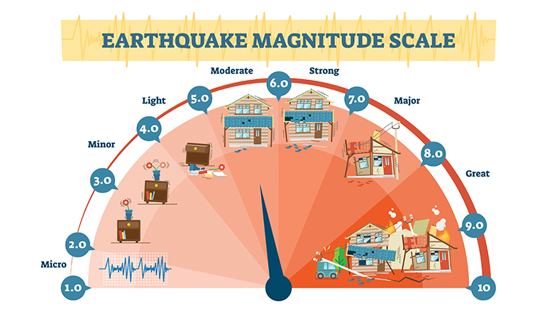
Kusala Rajendran was a PhD scholar in the U.S. in 1992, a time when most geologists and seismologists in that country were focused on the Parkfield experiment. Parkfield is a region in California through which the San Andreas Fault runs, and where six earthquakes of a magnitude (M) of 6 had occurred roughly every 22 years between 1857 and 1966. Some scientists predicted that another M6 temblor in the region was expected between 1985 and 1993.
"I was set to defend my thesis when I got a call early in the morning that there had been a small quake in Parkfield and the external examiner had rushed there instead, in anticipation of the promised (major) quake," recalls Rajendran, co-author of The Rumbling Earth (2024) and Earthquakes of the Indian Subcontinent (2022).
That quake did not happen. The next major one occurred in 2004, but not precisely where scientists had expected it to take place. "The science to accurately predict the time, area and magnitude of an earthquake is still not there," says Rajendran, now retired from the Indian Institute of Science, Bengaluru.
Earthquakes are complex phenomena, and no two are identical, even in the same region, says Bhaskar Kundu, Assistant Professor, Department of Earth & Atmospheric Sciences at the National Institute of Technology (NIT) Rourkela. "Proper scientific studies into seismology began only in the 1960s. Unlike the monsoon, which occurs every year, earthquakes have no regularity. So we do not even have enough data yet to understand the finer workings of earthquakes," he says.
SMARTPHONE SEISMOMETERS
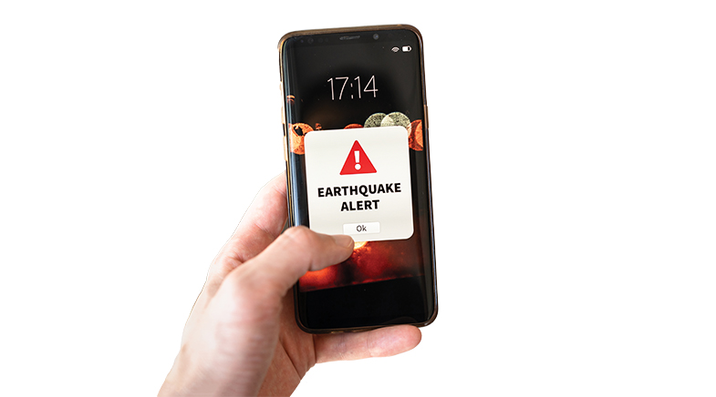
The science to detect the occurrence of an earthquake, however, has advanced, with more sensitive seismometers picking up the early signal or Primary (P) wave, leading to an early warning. The most recent system, initiated by technology giant Google, became a talking point after researchers from Google and UC Berkeley Seismology Lab published a paper on its Android-based earthquake detection and early warning alert system (bit.ly/Google-alert).
Sensitive seismometers are picking up the early signal or Primary wave, leading to an early warning. The most recent system was initiated by technology giant Google.
The paper reports the performance of the crowd-sourced system over an operational period of three years (2021 to 2024), covering major tremors. The system relies on the density of Android smartphones in a region. Their in-built accelerometers act as tiny seismometers. When stationary devices sense seismic activity, they relay it to the Google servers, along with the location.
The servers search for seismic sources consistent with the trigger in time and space, the paper explains. The magnitude, epicentre and time of origin are calculated, and the alert for the earthquake is sent out. "As Android phones represent 70% of all smartphones globally, this system provides an earthquake detection capability, wherever there are people, in both wealthy and less wealthy nations," the paper states. It has been used to send alerts in 98 countries so far.
The authors say that the Android Earthquake Alert (AEA) is still a work in progress. For instance, during the period covered in the study, it issued three false alarms: two because the system confused thunderstorms with earthquakes, and the third due to vibrations caused by a mass messaging event. Those glitches were subsequently removed from the system.
The alert gives a warning — from a few seconds to around a minute before a tremor — that allows people to rush outdoors or take cover. As Marc Stogaitis, Principal Software Engineer, Android, Google, writes in a blog, "The goal is to warn as many people as possible before the slower, more damaging S-wave [secondary wave] of an earthquake reaches them."
The AEA, however, is not entirely reliable yet. During the Turkey quakes of February 2023, it gave out a warning designed for light shaking for the first quake, which had a magnitude of 7.8. The paper addresses the drawback in the system for assessing magnitudes of major earthquakes, and says the AEA is improving in this aspect. What's not known is how a 35-second warning would have saved lives, given that the quake occurred at 4:17 am, when most were asleep.
The magnitude of a quake indicates not just its likely impact, but also how far the tremors will travel. While an underestimation can understandably be dangerous, overestimation erodes trust in the system. Stogaitis writes: "The challenge lies in the trade-off between speed and accuracy. The first few seconds of an earthquake provide limited data, but every second you wait to issue an alert is a second less of warning for those in the path of the shaking."
India has earthquake warning systems, issued through the BhooKamp app developed by the National Center for Seismology. The Uttarakhand State Earthquake Early Warning System, developed with help from the Indian Institute of Technology Roorkee, has been operational in the seismically vulnerable State since August 2021. It has successfully detected and, within seconds of the detection, given alerts for small quakes through its BhuDev App. No major earthquake has occurred in the area since the launch.
ON AI ALERT
Elsewhere, researchers are developing artificial intelligence (AI) models for monitoring and real-time prediction of quakes. QuakeFlow, developed in the U.S., is a cloud-based system that utilises machine learning to monitor earthquakes. Researchers from the Los Alamos National Laboratory studied Hawaii's 2018 Kīlauea quakes, which continued for three months. They utilised an AI model designed for speech recognition to predict the onset of a quake slip at the volcano, successfully doing so in several instances. But the researchers admit (bit.ly/speech-quake) the "results are not robust".
Researchers are also examining signals far above the ground — in the ionosphere, 80-600 km away — to monitor changes deep beneath the Earth's surface.
Munish Bhatia, Assistant Professor, Department of Computer Applications at NIT Kurukshetra, and his team have developed a model that combines the Internet of Things, sensor networks, edge computing and cloud-based AI for developing accurate, real-time detection and forecasting models (bit.ly/AI-alert). It, however, needs to be tested in a real-world situation.
SIGNALS IN THE SKY
Researchers are also examining signals far above the ground — in the ionosphere, 80-600 km away — to monitor changes deep beneath the Earth's surface. The ionosphere is a region of charged particles, and ionospheric seismologists observe disturbances in the Total Electron Content (TEC) during an earthquake. Ionospheric TEC disturbance was first detected over Alaska following an earthquake in 1964 through analysing Doppler records. "Data collection has improved significantly now with a constellation of Global Navigation Satellite Systems," says Kundu, whose laboratory also studies this field.
HIT AND MISS
The only quake in history to be accurately predicted was the Haicheng quake. On the afternoon of February 4, 1975, the Chinese seismic programme, then only a decade old, predicted an earthquake for the evening, after monitoring a range of indicators, including ground seismicity, foreshocks, groundwater seepage, and animal behaviour. This allowed time for evacuation, leading to minimal damage to human life in a town of 1 lakh people. However, the system was unable to forecast the Tangshan quake the very next year, which caused the death of over 240,000 people.
Researchers say that co-seismic TEC disturbance is caused when the ground-induced pressure waves of crustal movements propagate upwards as acoustic waves and reach the ionosphere. These have been detected during large earthquakes, a few minutes after the event. Researchers are now investigating the TEC disturbances that occur before the quake. Retrospective studies of recent big earthquakes indicate TEC disturbances much ahead of the main shock, ranging from a few minutes to several days (bit.ly/quake-TEC).
Some suggest that microcracking in the lithosphere during pre-seismic processes generates stress-activated currents. The ionosphere is coupled to these electrical currents through the global electric circuit. Ionospheric seismology is a relatively new area of investigation, and it is not entirely clear how seismic waves cause TEC disruptions. Moreover, the observations were found robust only in the case of quakes measuring at least M7.5. Smaller magnitude quakes can cause great devastation, depending on where they occur. The August 2025 quake in Afghanistan had a magnitude of 6, but the death count crossed 3,000.
Leading institutes globally are, however, researching quake prediction models based on ionospheric signals. Under the Massachusetts Institute of Technology's QuakeCast project, scientists are exploring technology that can predict an earthquake hours before it occurs — ranging from eight hours to a week — using machine learning to identify and classify TEC anomalies (bit.ly/MIT-QuakeCast). "There may be detractors today, but it is only a matter of time before we fully understand the phenomena," says Kundu. "The future of earthquake prediction is in the sky," he asserts.
Also read
Great shakes, it's a quake!


Pigment power
Melanin is being used in a host of fields — from beauty and biology to chemistry.

Reinventing buildings
Digital tools, new materials, and circular economics are reshaping the built environment.

The promise of therapeutic ultrasound
The ultrasound is lending itself to a swathe of new uses beyond diagnostics.
Have a
story idea?
Tell us.
Do you have a recent research paper or an idea for a science/technology-themed article that you'd like to tell us about?
GET IN TOUCH